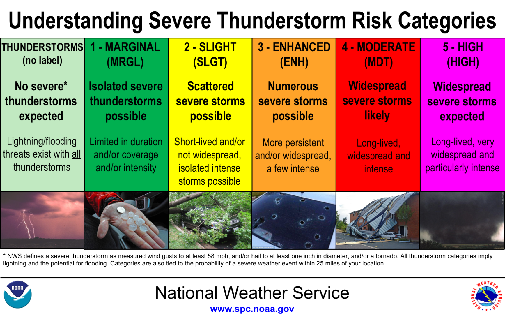
Using and Understanding Severe Thunderstorm Risk Categories
Each day, the Storm Prediction Center, an office of the National Weather Service, issues severe thunderstorm outlooks for the entire continental United States. These outlooks are issued for the current day and out to eight days. Emergency Management, Public Safety Agencies, the media, and others use these outlooks to make decisions for ensuring life safety and property protection. These outlooks have a scale of 1 to 5 with colors and words associated to communicate the risk category for a certain day.
When there is a risk of severe weather for Knox County on a certain day, that should be considered an “early warning” that severe weather may happen well before a Watch or Warning is issued and this time should be used to review and/or make adjustments to your safety plans, as necessary. These categories are often shared on the EMA Facebook page when necessary.
See the scale below for what each of the five categories represent.
Severe Weather “Watches”
On a day when severe thunderstorms or tornadoes appear more likely to occur, the Storm Prediction Center may issue a Severe Thunderstorm Watch or a Tornado Watch.
A Severe Thunderstorm Watch means that weather conditions have become favorable for severe thunderstorms to occur within this Watch area.
A Tornado Watch means that weather conditions have become favorable for severe thunderstorms along with a greater threat of tornadoes within the Watch area. Please note that the National Weather Service considers a thunderstorm to be severe if it contains wind gusts of 58 mph or greater, hail of one inch in diameter or larger, and/or a tornado.
Severe Weather “Warnings”
When a severe thunderstorm or tornado is likely or in progress, the local National Weather Service Forecast Office (for Knox County this is the Indianapolis office) will issued a Severe Thunderstorm Warming or a Tornado Warning. These warnings are issued based on the storm location and path. A Severe Thunderstorm Warning means that thunderstorm wind gusts are expected to be 58 miles per hour or greater or hail of at least one inch in diameter is expected. A Tornado Warning is issued when a tornado is spotted and in progress or if radar indicates a tornado is likely based on wind velocity detecting rotation.
Storm Based Warnings
Severe Thunderstorm and Tornado Warnings are NOT issued based on entire counties. Instead, these warnings are issued based on polygon areas that are drawn by meteorologists at the NWS office. This allows better targeting of people in the actual threat area instead of warning people where a storm will not affect.
Services such as CodeRED, use the storm based warning information to call registered users if their address falls within a warning polygon. Older legacy systems, such as the NOAA All Hazards Radio System, are still based on entire counties. By having a NOAA All Hazards radio, you can be notified if a warning is issued anywhere in the county then confirm your address is officially included in the warning by receiving a notification from CodeRED. This two source method provides redundancy and confirmation for severe weather warnings.
Outdoor Warning Sirens
Outdoor Warning Sirens should never be considered as a primary means of warning, especially while indoors. These sirens are only designed and intended to alert people who are outdoors and away from other sources of warning.
